Town Branch and Legacy Trails

Lexington, Kentucky is developing a comprehensive network of bikeways, walking paths, and trails. Unlike trail networks in many other cities, few of these trails are converted from abandoned railroad beds. What Lexington is doing is much more difficult. The city is fitting trails into the city infrastructure often without ready-made pathways. This requires ingenuity, commitment, and community support.

Successful trail projects provide inspiration and increase desire for more trails. Lexington’s Legacy Trail is a shining example. At over 12 miles in length and with plans to extend it toward Georgetown, it is currently the longest bike path in Lexington. Originally constructed for the 2010 Alltech FEI World Equestrian Games, the trail was designed to be a lasting legacy that would connect Lexington downtown to the Kentucky Horse Park, the site of the games. This well maintained paved trail provides a quick escape from the city into the restful rolling hills of the Kentucky bluegrass. Although not a rail-trail, it provides similar benefits. This mostly off-street path features historic sites and interpretive signs, art installations and sculptures, and beautiful rural countryside.

Another legacy of Lexington is its water source. The city was founded in 1779 along the banks of the Town Branch of the Elkhorn Creek. Already in development and funded for almost all of the rest, the Town Branch trail will follow alongside this important water course from the west side of Lexington, through Lexington’s historic Bourbon Distillery District, cross downtown, and connect with the Legacy Trail.

This combined trail system will provide a delightful bicycle and pedestrian friendly route through Lexington. I’m excited to watch it develop.
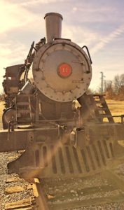
Riney-B Park and Trail

Compared to other states, Kentucky has few rail-trail project miles, but progress is being made. One trail constructed in the past 5 years is a short section of the former Riney-B railroad bed in Nicholasville, Kentucky. The trail begins at the parking lot of the KentuckyOne Health St. Joseph Jessamine-RJ Corman Ambulatory Care Center. You can also reach it by entering at the main Riney-B Park entrance and walking up the hill to the right of the aquatic center. Although the paved trail is less than a mile in length, it is loosely connected into the disc golf course trails that provide a loop around the park. The park also has a 1925 Baldwin steam locomotive on display that is similar to those Baldwin manufactured for the Riney-B.

The Riney-B name comes for the Richmond, Nicholasville, Irvine and Beattyville railroad (know by its initials RNI-B) that operated from the 1890s to the 1930s. The railroad also reached Versailles. In August 1899, the Riney-B was acquired by the Louisville & Atlantic railroad, which was subsequently purchased by the Louisville & Nashville railroad in July 1909. When a bridge washed out in the Logana area of eastern Jessamine County in 1932, the L & N abandoned the line.

Kentucky Abandoned Railbeds

During the Kentucky Rails to Trails Council (KRTC) meeting tomorrow (Tuesday) at 6:30pm, Lisa Brownell will do a presentation on her work on the Kentucky Abandoned Railroad Corridor Inventory. She will describe abandonments that have good potential to become rail-trails. Lisa is a gifted presenter and this should be a informative and enjoyable talk.

KRTC meetings are open to all KRTC members and interested rail-trail supporters. Meetings are held at the Lexington Fayette Co. Urban Co. Government Building at the corner of Main St. and Martin Luther King Blvd. (next to the Kentucky Theater) in Lexington, Kentucky. Parking is available across the M.L. King viaduct behind the Police and Driver’s Registration.

All aboard for Kentucky rails-to-trails

Today’s Lexington Herald-Leader had two informative and postive articles about rail-trails in Kentucky. It’s exciting to see people discussing rail-trails and their health benefits.

The first article describes how initial opposition turned into enthusiasm for a rail-trail in Muhlenberg County. I enjoyed hearing Muhlenberg County Judge-Executive Rodney Keith Kirtley, who is quoted in the article, speak at the 2004 Kentucky Rails to Trails Conference. He is a gifted speaker and very optimistic about rail-trails in Kentucky.

From the article:

When Muhlenberg County officials unveiled plans to turn an unused railroad right-of-way into a public walking and biking trail, property owners along the route ran roughshod over the idea.

What a difference a couple of years can make.

The 6-mile trail between Greenville and Central City, which opened in 2002, has become one of the most popular projects the county has ever undertaken, Kirtley said. And, he said, it’s starting to help county residents shed pounds and become more healthy.

Interestingly, Kirtley said, some of the trail’s most vocal critics have become its most ardent supporters.

“The funny thing is that within a month after the trail opened, a lot of the people who had fought it were out there walking,” he said. “The very gentleman who started all the petitions and everything, he bought a bicycle and started riding the trail every day.”

The second article emphasizes the physical fitness problems of rural Kentucky and mentions that rail-trails can provide safe recreation areas:

In many rural counties, finding a place to exercise is a major roadblock.

Many once-quiet country roads are abuzz with traffic today and are too narrow for safe or pleasant walking. Fitness centers outside of town are almost unknown. One of the ironies of the obesity epidemic is that the once-sturdy country farmer — who is more likely today than a generation ago to be overweight, thanks to labor-saving machinery — might have to drive to town to find a place to exercise.

But finding a place in many smaller towns can be tough. Many lack places for indoor exercise or walking, or even commercial programs, such as Weight Watchers. Even when such places or programs are available, many working families might not be able to afford them, officials say.

“For every dollar we spend on ourselves for fitness, we’re paid back threefold in better health,” said Theresa Scott, extension agent in Floyd County, which launches its Get Moving program today. “That’s a good investment, but it can be tough when you’re already making car payments, buying kids’ braces, and all that. One thing we really need is affordable facilities to promote exercise.”

Sounds promising for rail-trails to me.

History of Young’s High Bridge

I’ve been researching the history of Young’s High Bridge. Like the High Bridge, this is a railroad cantilever bridge crossing the Kentucky River. Young’s High Bridge, also called the Tyrone Bridge due to its close proximity to Tyrone, Kentucky, was constructed in roughly six months during 1889. A somewhat spindly looking bridge, it never received much railroad traffic, certainly not as much as High Bridge. The bridge has never been strengthened or modified, but remains today as it was orginally constructed. With its elegant angles it is a delightful bridge to view. The last train crossed the bridge in November 1985. The railroad lists the bridge as out of service and has abandoned the line.

I’ve had the pleasure of speaking with Jodie Wells, a Bluegrass Railroad Museum member, and the president of the Tyrone Bridge and Rail Company, a non-profit organization working to save the bridge. They are seeking to get the bridge listed on the Historic Landmark Registers in order to make it eligible for federal and state preservation grants. They are also raising money that they hope will one day help make the historic bridge a tourist attraction and state park. She points out how difficult it would be for a private organization to handle the liability on the bridge, but that it would be a different issue altogether as a state park.

With the nearby Wild Turkey bourbon distillery, and miles of abandoned line, this would make a beautiful biking and walking trail. Wells points to a similar project in Pennsylvania that she uses as a model: the Kinzua bridge and park. The Kinzua bridge was unfortunately partially destroyed by a tornado shortly after the start of a multi-million dollar strengthening project earlier this year, pointing out the urgency for preserving these aging structures. See the Kinzua Bridge Foundation for more details.

If the Tyrone Bridge and Rail Co. are not able to raise the necessary funding, there’s a good chance the bridge will be destroyed. Wells estimates that they need to raise a $5 million endowment as a starting point. Although that’s a significant amount, it may not be so unreasonable when you consider that cost estimates for taking down the bridge are in the $1 million range.

“I’ll guarantee you this,” Wells says, “if we can’t do it, it won’t be done.”

To contribute to the endowment or for more information write the Tyrone Bridge and Rail Co., P.O. Box 1202, Versailles, Ky. 40383.

Historic High Bridge color photos

The Elmer L. Foote Lantern Slide Collection has a number of pictures of High Bridge, including some of its original construction and some of the reconstruction. The collection is fairly large and includes many waterfall pictures as well as pictures of various mountain folk. The High Bridge photos begin around number 80 in the collection. Don’t miss slide 81 which shows the reconstruction of the bridge from near the stone towers. Slide 91 shows the completed bridge from the towers.

The pictures in this collection were taken by Foote, who was a Cincinnati photographer and public library staff member. His pictures appeared in the Cincinnati Commercial Tribune. Many of the slides are hand-tinted, which lends an almost color photograph feel. I love that the Kentuckiana Digital Library is making these pictures available.

Transportation trails in Kentucky

On November 19, I attended a meeting of the transportation advisory committee for the Jessamine County portion of the US 68 widening project. Part of the discussion was about what pedestrian and bicycling facilities needed to be included in the project. Kentucky Transportation Cabinet policy requires that these facilities be considered in every construction project.

The advisory committee ended up recommending that the road include wide shoulders for bicycle use from Lexington up to Catnip Hill road. At that point, the old Harrodsburg road will be used as both a bike route and for automobile traffic—it is expected that far fewer cars will be using the old road. The bicyclists and pedestrians will then join a shared use path for non-motorized vehicles only. It will cross under US 68 using a new tunnel (almost 150 feet long). The path will continue along Harrodsburg road up to KY 29.

I was a little surprised that most of the bicycle advocates wanted wide shoulders and to stay on the road. I was much more interested in the possiblity of a path along the road that could be used for various forms of exercise, including walking, running, strolling, biking, and skating. Walking beside a four lane highway on a shoulder isn’t that enjoyable. The advisory committee doesn’t want this to look like an interstate highway, so concerns for preserving the beauty of Harrodsburg road using grass shoulders won out. This led to recommending a separate 12 foot wide path. Similar concerns meant that we get a tunnel instead of a bridge crossing the road.

I was thrilled with the strong support of a number of bicyclists and those friends of rail-trails. It would be wonderful to be able to bicycle from Lexington to High Bridge along safe trails. There’s still work to be done to make that a reality. Wilmore would need to extend its existing trail from the veteran’s center out to Ky 29. And there’s the High Bridge rail-trail that would provide the last portion from Wilmore to High Bridge.

I’m excited about the future possibilities. I’ve dreamed of biking to work from Wilmore, but the present road conditions make it unsafe. The new path is a dream come true. Having this path may help tourism in Jessamine county and those living along Harrodsburg Road will also enjoy it.

So many standards

Alana posted the old story about how the US standard railroad width of 4 feet 8½ inches is derived from the Roman chariot’s width. It’s a fun story about how government specs live forever. Go read it and then come back for my Paul Harvey impersonation.

While it’s true that the modern standard gauge in the US matches the British gauge, it wasn’t always obvious that that would be the case. For quite a while the 5-foot gauge was popular, especially in the South. In various parts of the country, gauges varied from 2½ all the way up to 6 feet. It wasn’t until the end of the Civil War and the need for the reconstruction of the South that it became obvious that a standard gauge was needed. Even then, although most of the North was using 4′8½″, the need for many railroads in the South to interconnect with the Pennsylvania Railroad led to moving the entirety of the South to the Pennsy standard of 4′9″. It wasn’t until years later that the popularity of the current standard gauge won out. Now you know.

You can read much more about this in the article “The Days They Changed the Gauge” from the August 1966 Ties magazine. The article tells the story of the dramatic change over of an estimated 11,500 miles of track to the 4-foot 9-inch gauge in just two days of May 1886.

As an aside, I find it surprising to myself that this is the first post by Alana that I have commented on. Perhaps I’ll just say that I’m still thinking about her post on ritual and Seraphim’s comments about it. So true.

Kentucky’s abandoned railroad lines

I’m thrilled to announce that there is now a website for the Kentucky Abandoned Railroad Corridor Inventory. Packed with beautiful pictures, clear and accurate maps, and abandoned line descriptions, the site is a joy to read. Especially enjoyable are the highlighted lines. Having driven past some of them, and having enjoyed similar trails in Ohio and Michigan, I can visualize how wonderful they would be converted to bike trails. You can also get the full report in PDF format.

The abandonment inventory is a great tool for rails to trails organizations. Of the roughly 1,200 miles of abandoned lines available in Kentucky, only about 15 miles have been converted for trail use. This means Kentucky ranks 47th in the states in terms of rail-to-trail conversions. Only Delaware, Alaska, and Hawaii have fewer miles. I hope that this inventory will help others see the possibilities and that we will soon be able to celebrate many more rail-trails in Kentucky.

The Rathole Division

For a while now I’ve been trying to determine exactly when the old railroad bed between Wilmore and High Bridge was abandoned. As I noted on the doubling the tracks page of my High Bridge history, I thought it was in 1929. I found a new source that seems to confirm that date.

The article 90 Years to “Daylight” in the August 1963 issue of Ties: the Southern Railway System Magazine is a fascinating look at the history of the section of the Cincinnati, New Orleans & Texas Pacific (CNO&TP) Railway that gained the nickname the “rathole division”:

“That nickname once aptly characterized the middle section of the CNO&TP, where 27 tunnels helped the line traverse 160 miles of rugged mountain country between Wilmore, Ky., and Emory Gap, Tenn., and kept an assortment of civil engineers busy almost from the day the line opened for traffic.

Tunnels were numbered 1 through 27 (running from north to south). They ranged in length from 3,992 feet (tunnel No.2–Kings Mountain) to 189 feet (tunnel No.6). Trains traveled underground for five miles through these 27 tunnels.

Tunnel openings were designed to be approximately 15* feet wide and 20 feet high at the top of the arch. Some of the arches appeared almost round, some resembled flat topped triangles, others were more jagged in appearance. The blasting techniques of the 1870’s left something to be desired.

Trains thundered through the tunnels for almost a decade before the next abandonment about 1930. This was tunnel No.1 and it too was bypassed as a result of installing double track, this time near Wilmore, Ky.…”

There’s also a beautiful cover picture of High Bridge on the April 1948 issue and a two page spread of High Bridge in 1905 in the January-February 1981 issue.